Whiting Street PD&E Study
We have a new preferred alternative! Check it out below.
Check out what is proposed!
What is this study?
The Tampa Hillsborough Expressway Authority (THEA) is conducting a Project Development and Environment (PD&E) Study to connect Whiting Street to Meridian Avenue to improve the street network in eastern downtown Tampa. We are also looking at ways to improve operations and safety for Whiting Street between Jefferson Street and Brush Street, the Jefferson Street entrance ramp, and the downtown Tampa eastbound exit ramps. We’re looking at potential improvements that will enhance safety and community connections in downtown Tampa.
This website presents the preferred alternative for making the improvements, as well as the alternatives that were initially developed and evaluated and the process we have taken to get where we are.
See below the map below to learn more about the locations where improvements are being planned.
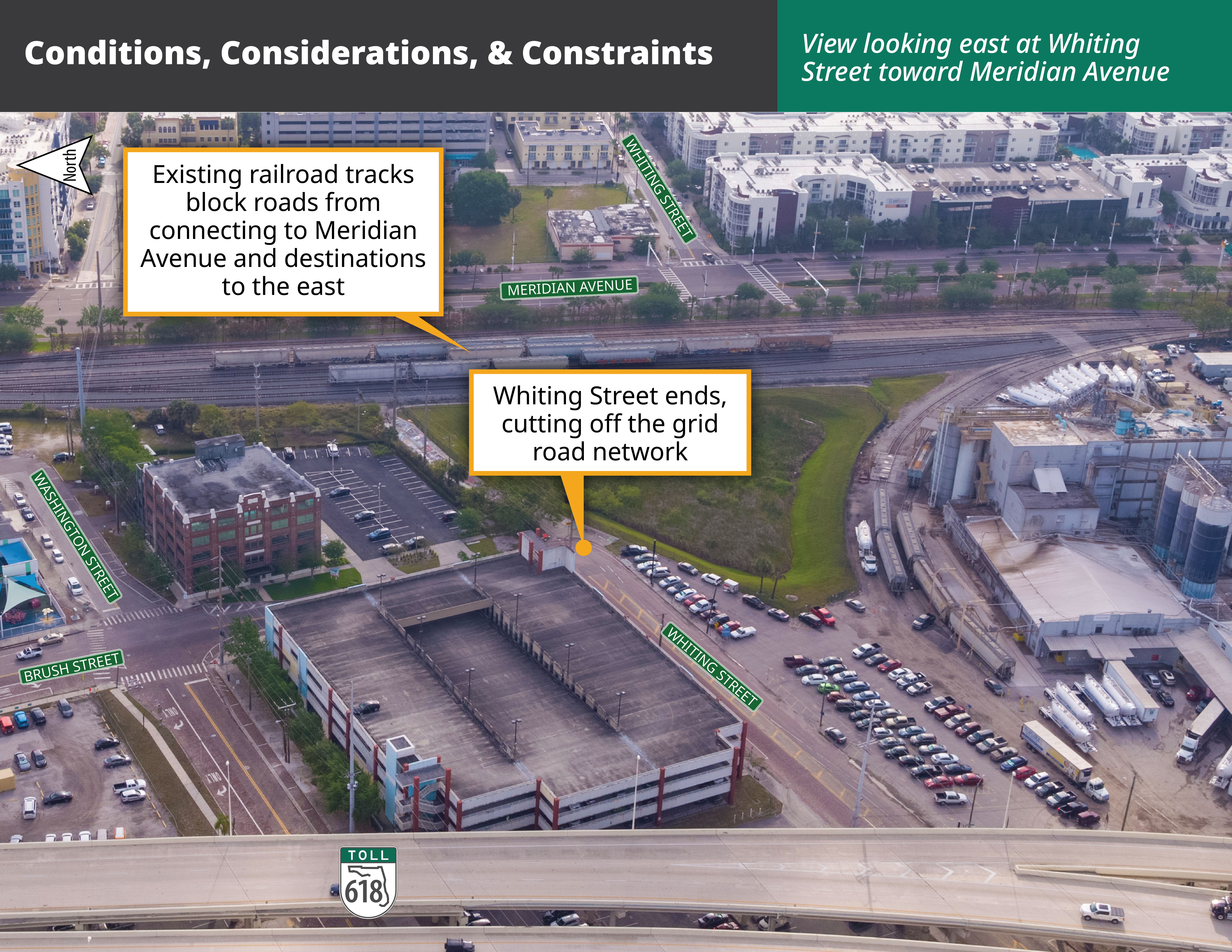
Improvement Location A: Whiting Street from Meridian Avenue to Brush Street
The study is looking at ways to complete the grid network by extending Whiting Street between Meridian Avenue and Brush Street, where it currently ends.
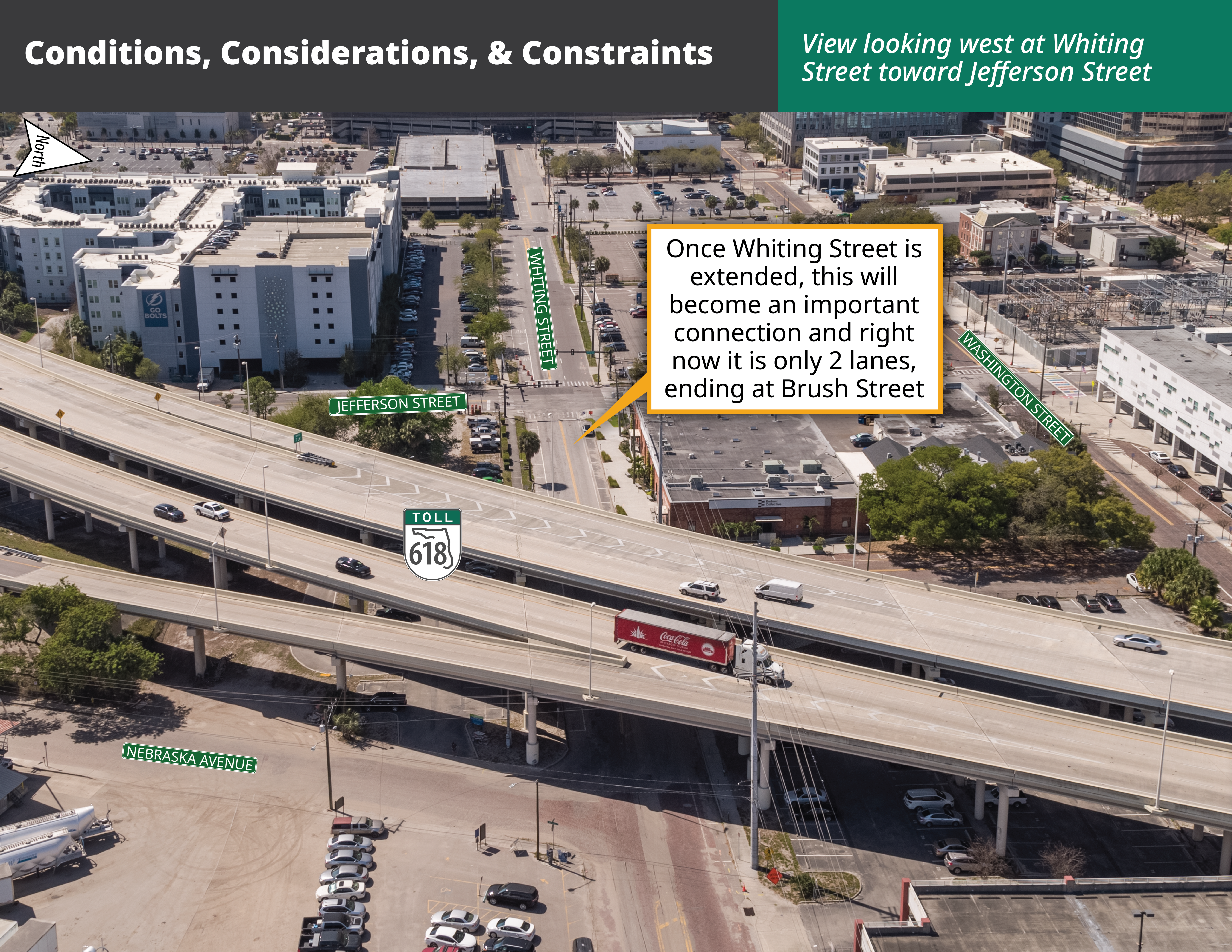
Improvement Location B: Whiting Street from Brush Street to Jefferson Street and the Intersection at the End of the New Whiting Street Exit Ramp
The study is looking at improving Whiting Street between Brush Street and Jefferson Street, including the intersection at the end of the new exit ramp for Whiting Street (Exit 6B).
Improvement Location C: Jefferson Street Entrance Ramp and the New Whiting Street Exit Ramp
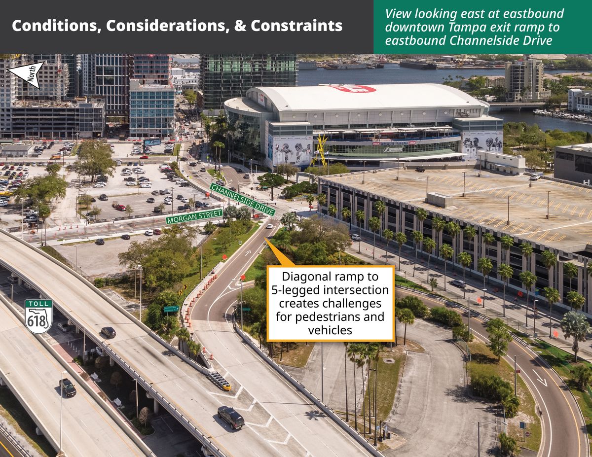
The study is looking at a new exit ramp for Exit 6B (which currently connects to Channelside Drive), moving it to the northeast to connect to Whiting Street (see Location D). This would require the beginning of the Jefferson Street entrance ramp to shift to the north.
Improvement Location D: Removal of Exit Ramp 6B and Reconstruction of Exit Ramp 6A
Once the ramp for Exit 6B is moved to the northeast (see Location C), the existing ramp for Exit 6B would be removed and the ramp for Exit 6A to northbound Florida Avenue would be lengthened and widened.
Improvement Location A: Whiting Street from Brush Street to Meridian Avenue
The study is looking at ways to complete the grid network by extending Whiting Street between Meridian Avenue and Brush Street, where it currently ends.
Improvement Location B: Whiting Street from Jefferson Street to Brush Street including an Intersection at the End of the New Whiting Street Exit Ramp
The study is looking to improve Whiting Street between Jefferson Street and Brush Street, including the intersection at the end of the new exit ramp for Whiting Street (Exit 6B).
Improvement Location C: Jefferson Street Entrance Ramp and the New Whiting Street Exit Ramp
The study is looking at a new exit ramp for Exit 6B (which currently connects to Channelside Drive), moving it to the north to connect to Whiting Street (see Location D). This would require the beginning of the Jefferson Street entrance ramp to shift to the north.
Improvement Location D: Removal of Exit Ramp 6B and Operational Improvements to Exit Ramp 6A
Once the ramp for Exit 6B is moved to the northeast (see Location C), the existing ramp for Exit 6B would be removed. A pedestrian signal (called a Rectangular Rapid Flashing Beacon) would be added to the end of the ramp for Exit 6A where it meets northbound Florida Avenue.
Why are we studying this project?
When THEA reconstructed Meridian Avenue, we made a commitment to the community that once the Ardent Mills flour mill was no longer located in downtown Tampa, we would remove the railroad tracks and help to restore the street network, connecting the center portion of downtown Tampa to the east. Now that the flour mill has moved, we are following through on that commitment. We are excited about how downtown is changing and growing, and we want to be part of the solution that makes getting around safer and easier.
Improve the Grid Road Network
The railroad tracks that run parallel to Meridian Avenue currently cut off Whiting Street from connecting to the east. Once the railroad tracks are removed, completing these connections to Meridian Avenue will provide a better grid-style road network in this area. Enhancing the east-west connectivity by connecting streets that are now cut off will make moving around the area safer and easier, and give more options for drivers, pedestrians, and bicyclists.
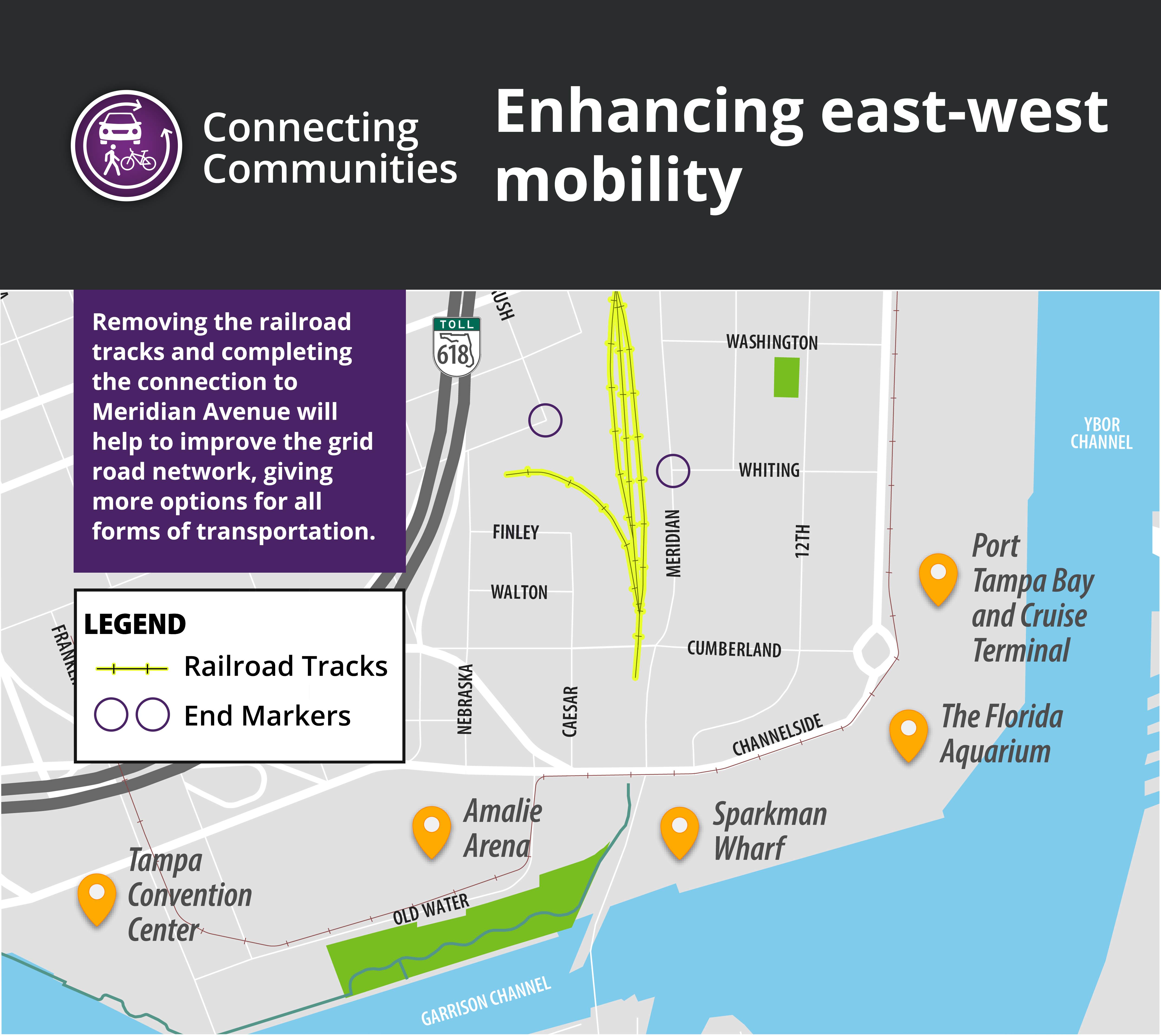
View East-West Connectivity Map
Accommodate Increased Traffic
New development is underway and bringing exciting changes to the southern portion of downtown Tampa. These changes will bring more people to the area, which means more cars, pedestrians, scooters, and bicycles. In addition, the planned improvement to the Selmon Expressway south of the downtown exit ramps will alleviate congestion along the Selmon. However, the configuration of the existing exit ramps does not accommodate the anticipated increase in traffic that is projected in the future.
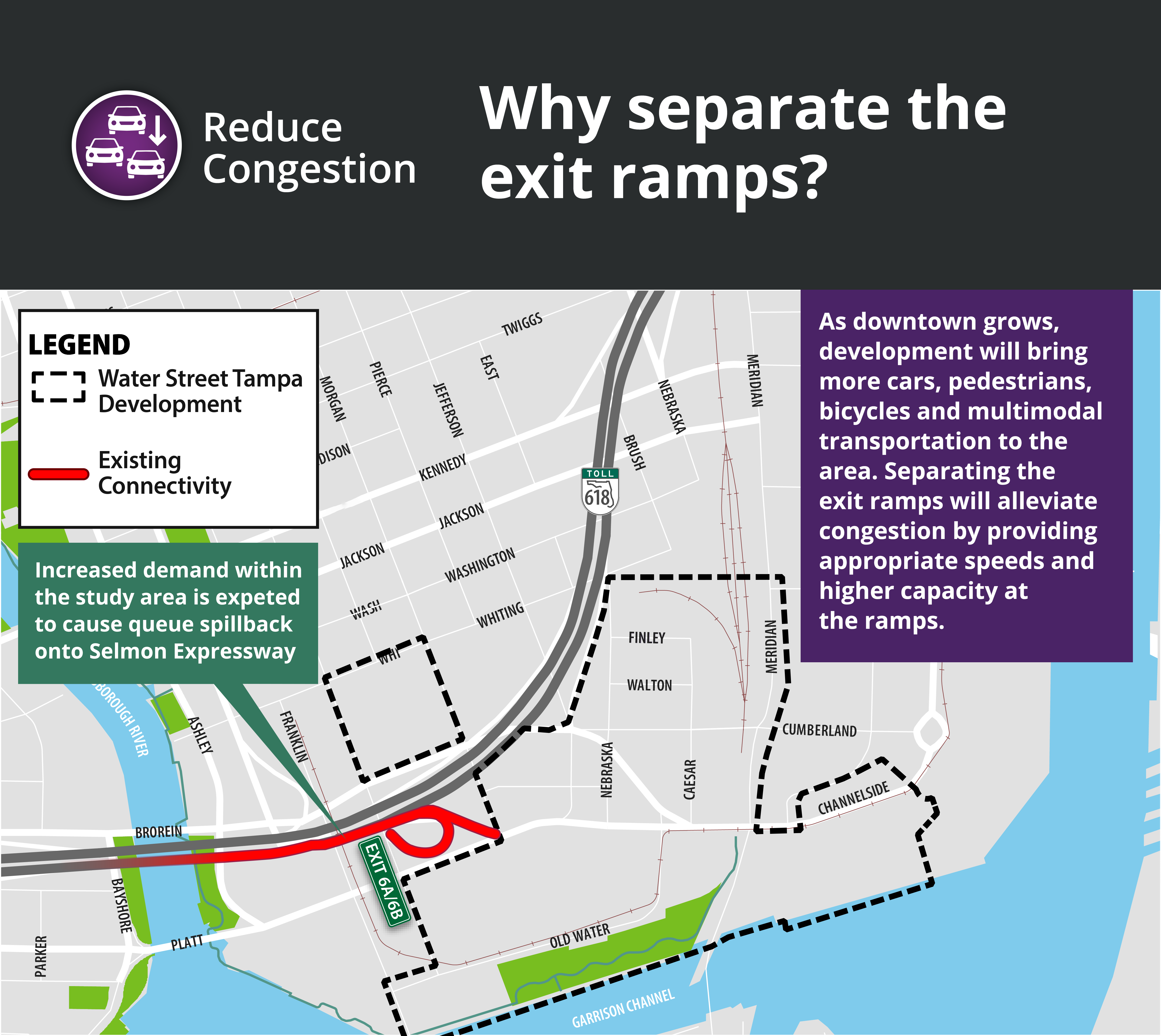
View the No Build Map
What are the conditions out there today that helped guide the study?
Click on the images below to see the conditions, considerations, and constraints that went into developing the preliminary build alternatives.
Location A: Whiting Street from Meridian Avenue to Brush Street
Location B: Whiting Street from Brush Street to Jefferson Street and the Intersection at the End of the New Whiting Street Exit Ramp
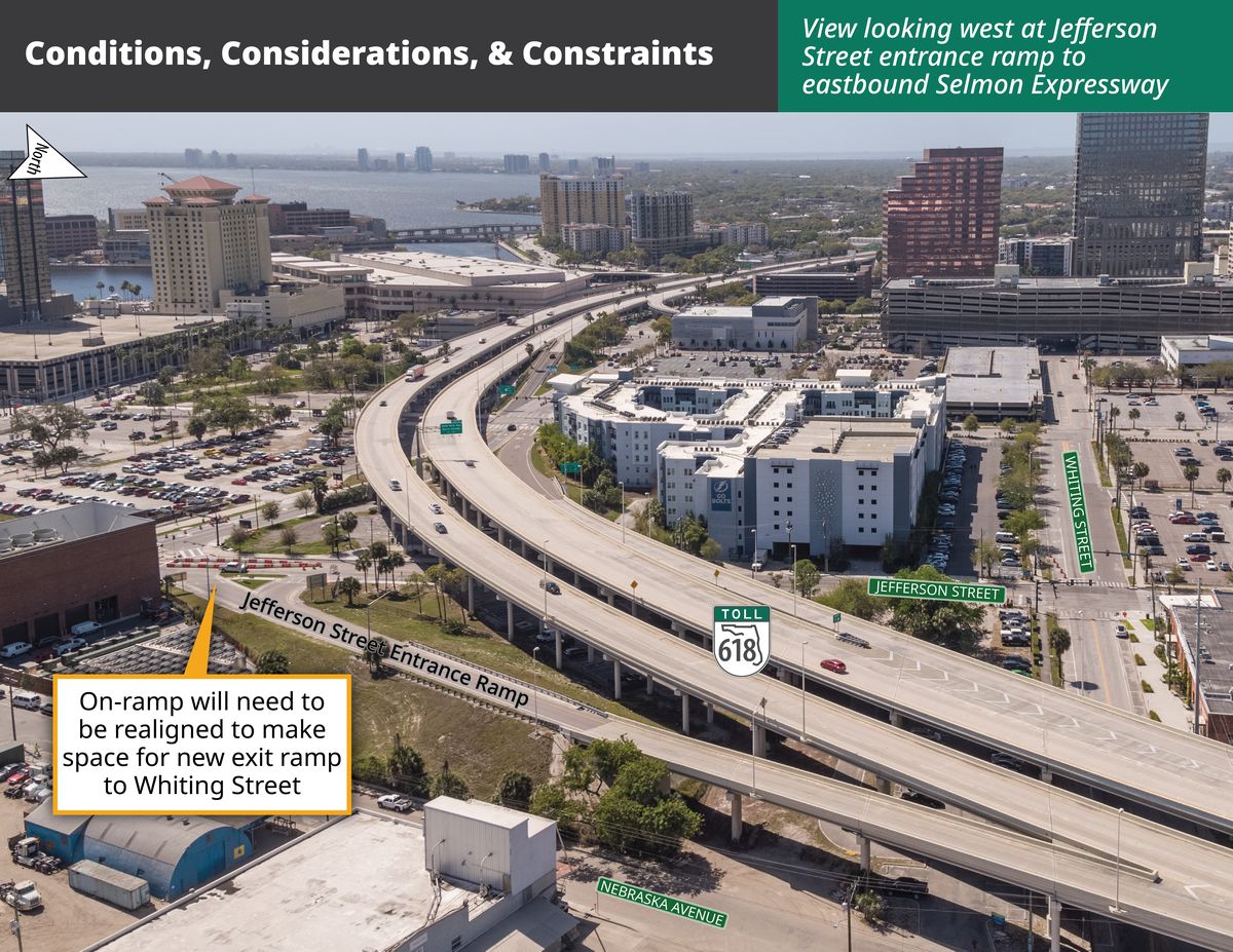
Location C: Jefferson Street Entrance Ramp and the New Whiting Street Exit Ramp
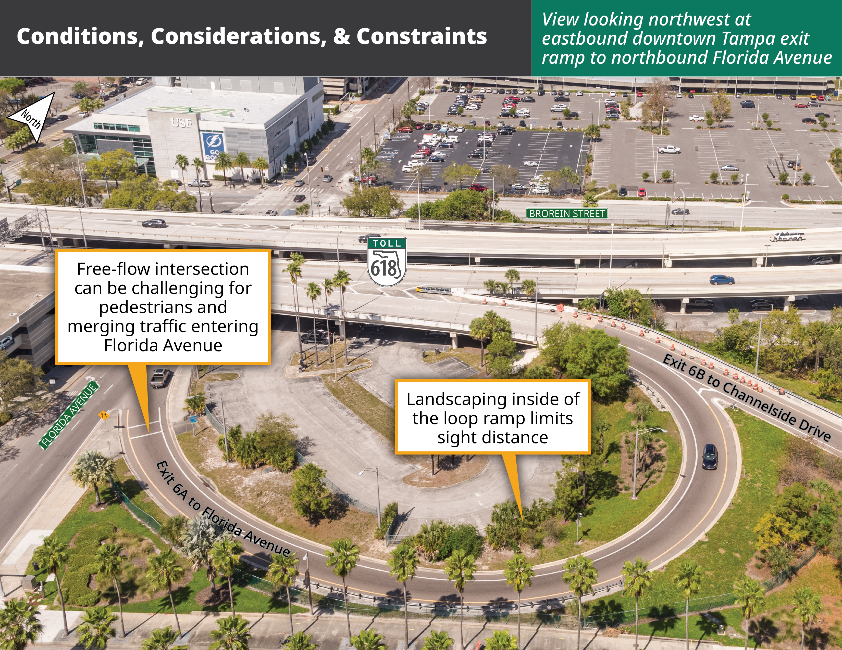
Location D: Removal of Exit Ramp 6B and Operational Improvements to Exit Ramp 6A
Location D: Removal of Exit Ramp 6B and Operational Improvements to Exit Ramp 6A
What is our process?
For a project to be constructed, there is a process it must follow. Right now we are in the PD&E Study phase. A PD&E Study is an environmental and engineering process developed by the Florida Department of Transportation to look at the social, economic, natural, and physical environmental impacts of different alternatives in an effort to address a transportation challenge or need. The PD&E process is conducted openly to ensure there are no disproportionate impacts to the community.
The PD&E Study process includes four steps –
- Develop Alternatives
- Evaluate Alternatives
- Gather Public Comments
- Select Preferred Alternative
Read through each of the four steps below to see our process, a summary of the alternatives that are being considered, and how the Preferred Alternative will be identified. Please note, a No Build alternative is being considered throughout this study process.


Two preliminary alternatives have been developed based on the conditions out there today and to address the purpose and need of the project, including the anticipated conditions in the future (discussed above).

After the two preliminary build alternatives were developed, the team evaluated each to determine how well they address the purpose and need of the project.

Working with the community to ensure the best possible outcome of this study is of utmost importance to THEA. The public information meeting held in May 2021 allowed members of the community to review the alternatives and their potential impacts, and provide comments and ask questions about the project.

All public comments received thus far were used to help the team refine the alternatives and identify the preferred alternative. The preferred alternative is described below.
On February 22, 2022, a Public Hearing was held at the THEA boardroom to present the project’s preferred alternative to the general public, project stakeholders, and other interested parties. Based on comments received during this hearing, and during subsequent meetings with project stakeholders such as the City of Tampa, it was determined that the project preferred alternative should be revised to only address proposed improvements to Whiting Street and its connection to Meridian Avenue, and the removal of the eastbound Channelside Avenue off-ramp and replace it with a ramp connecting to Whiting Street. The Florida Avenue off-ramp would remain one lane, and a rectangular rapid flash beacon (RRFB) pedestrian signal would be added at the ramp’s connection with Florida Avenue.
The new preferred alternative is discussed below.
What is the preferred alternative?
The following describes the preferred build alternative. The information is organized by the four locations above (A-D). Each location includes a plan view map with the improvements highlighted.
Location A: Whiting Street from Meridian Avenue to Brush Street
At this location, we will fulfill our commitment to the community to restore the street network. Right now, Whiting Street is cut off by the railroad tracks that run north-south next to Meridian Avenue. The preferred alternative would construct a new portion of Whiting Street to connect Brush Street to Meridian Avenue north of the existing intersection of Whiting Street and Meridian Avenue.
A new traffic signal would be installed at the intersection of Brush Street and Whiting Street. The new portion of the Whiting Street would have 2 lanes in the eastbound direction, 1 lane in the westbound direction, and a separated 2-way cycle track on the north side of the road. Wide sidewalks would be constructed on both sides of the road. On Meridian Avenue, the grass median would be separated at the new Whiting Street connection to include a northbound dedicated left turn lane from Meridian Avenue to Whiting Street and the median would also be separated to feed a southbound left turn lane from Meridian Avenue to Whiting Street.
This would improve the street network for this area and allow for the grid to be expanded in the future. This also provides an additional crosswalk opportunity, which would improve pedestrian convenience and safety. The new signal at Meridian Avenue would be coordinated to operate with the existing signal to the south to ensure efficient flow of the traffic.
Click on the image below to see all of the improvements in this location as part of the preferred alternative.


Location B: Whiting Street from Jefferson Street to Brush Street including an Intersection at the End of the New Whiting Street Exit Ramp
The preferred alternative would bring the existing portion of Whiting Street from 2 lanes to 3 lanes, with 2 eastbound lanes and 1 westbound lane. A separated 2-way cycle track would be added to the north side of the road. Left turns from Jackson Street would be restricted to improve safety and traffic flow.
The existing ramp for Exit 6B would be moved to the north to connect to Whiting Street instead of Channelside Drive (see Location D). This would create a new intersection where the new 6B exit ramp would connect to Whiting Street.
The new ramp would have three lanes where it meets Whiting Street. One lane would turn left (west) onto Whiting Street and two lanes would turn right (east) onto Whiting Street. Enhanced crosswalks would be constructed on either side of the ramp to cross Whiting Street and at the end of the ramp.
Click on the image below to see all of the improvements in this location as part of the preferred alternative. Please note, improvements for Locations B and C are shown together.

Location C: Jefferson Street Entrance Ramp and the New Whiting Street Exit Ramp
As part of the preferred alternative, the existing ramp for Exit 6B would be moved to the north to connect to Whiting Street instead of Channelside Drive (see Location D). The ramp would begin with 1 lane and end with 3 lanes, 1 for turning westbound (left) and 2 to turn eastbound (right) onto Whiting Street. Moving the ramp for Exit 6B would require two modifications to what is out there today. The beginning of the entrance ramp from Jefferson Street to the eastbound Selmon Expressway would move to the north to make room for moving Exit 6B. And a connection between Nebraska Avenue and Finley Street would be constructed.
Click on the image below to see all of the improvements in this location as part of the preferred alternative. Please note, improvements for Locations B and C are shown together.
Location D: Removal of Exit Ramp 6B and Operational Improvements to Exit Ramp 6A
Right now, both eastbound downtown exits, Exit 6A and 6B, leave the Expressway at the same point. Separating the exit ramps and moving Exit 6B to the northeast will make this area safer. Once the exit ramp for Exit 6B moves to the northeast, the existing pavement for the diagonal ramp would be removed.
Modifications to Exit 6A would include lengthening the striping for the exit to begin earlier. Safety improvements to the loop ramp would include adding a high friction surface, adding a pedestrian signal at the ramp’s connection with Florida Avenue, and removing the existing landscaping within the inside of the ramp loop to improve sight distance.
Click on the image below to see all of the improvements in this location as part of the preferred alternative.

What is the schedule?
The PD&E Study was completed in 2024.
Resources and Reports
Comments and Coordination Report (updated)
Contamination Screening Evaluation Report Appendix B (updated)
Cultural Resources Assessment Survey
Cultural Resources Assessment Survey - Pond Addendum
Cultural Resources Assessment Survey - Pond Addendum Concurrence Letter
Cultural Resources - Case Study Report
Cultural Resources - Case Study Concurrence Letter
Cultural Resources - Concurrence Letter
Geotechnical Technical Memorandum (updated)
Location Hydraulic Report (updated)
Natural Resources Evaluation (updated)
Noise Study Report (updated)
Pond Siting Report (updated)
Preliminary Engineering Report (updated)
Project Environmental Impact Report (updated)
Project Traffic Analysis Report Appendix A-B Appendix C-D Appendix E-J Appendix K (2022)
Project Traffic Analysis Report (2024)
Sociocultural Effect Evaluation
Public Information Materials
Check out the latest project video
Presentation to THEA Board (February 26, 2024)
The presentation regarding Whiting Street given at the board meeting is provided below.
Public Hearing (February 22, 2022)
Thank you for attending the February 22, 2022 public hearing. The materials and videos presented at the meeting are provided below.
Click here to view the Handout given at the hearing
Click here to view the Display Boards shown at the hearing
View the presentation shown at the February 22, 2022 Public Hearing
Public Information Meeting (May 20, 2021)
View the presentation recording from the May 20, 2021 Public Information Meeting
View questions and answers from the May 20, 2021 Public Information Meeting »
Submit a Comment
You may send a comment using the form below, by emailing us, or by mailing a comment. While you can send comments anytime, the official comment period for the Public Hearing closes at 5:00PM on March 8, 2022.
Email comments
Send email to whiting@selmonstudies.com
Mail comments
Communications Department
Tampa Hillsborough Expressway Authority
1104 East Twiggs Street
Suite 300
Tampa, FL 33602